
DEADMAN SPRING SE, NV

Geologic map of the Deadman Spring SE quadrangle, Lincoln County, Nevada
DELAMAR 3 SE, NV
Geologic map of the Delamar 3 SE quadrangle, Lincoln County, Nevada
GEOLOGIC MAP OF THE POINT DUME QUAD, CA
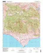
Geologic map of the Point Dume quadrangle, Los Angeles County, California
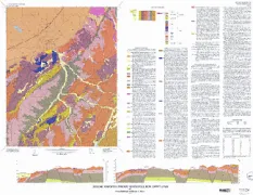
DEADMAN PASS, MT
Geologic map of the Deadman Pass quadrangle, Beaverhead County Montana, and Lemhi County, Idaho
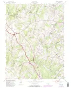
PURCELLVILLE, VA
Geologic map of the Purcellville quadrangle, Loudoun County, Virginia
PAROWAN, UT
Geologic map of the Parowan quadrangle, Iron County, Utah
GEOLOGIC MAP OF THE URBANA QUAD, MD
Geologic map of the Urbana quadrangle, Fredrick and Montgomery Counties, Maryland
CAVENDISH QUAD, WINDSOR CTY,VT, VT
Bedrock geologic map of the Cavendish quadrangle, Windsor County, Vermont
GEN AVAIL GRND WATER 25M, AR
General availability of ground water and depth to water level in the Arkansas, White, and Red River basins
AVERAGE RUNOFF & PRECIPITATION, NY
Average annual runoff and precipitation in the New England-New York area
BULLITT/JEFFERSON/OLDHAM COUNT, KY
Availability of ground water in Bullitt, Jefferson, and Oldham Counties, Kentucky (County group 22)
AVAILABILITY OF GROUND WATER MARION, KY
Availability of ground water in Marion, Nelson, and Washington Counties, Kentucky (county group 21)
LEWIS/ROWAN COUNTIES GROUNDWAT, KY
Availability of ground water in Lewis and Rowan Counties, Kentucky (county group 17)
CALDWELL/CHRISTIAN/CRITTENDEN/, KY
Availability of ground water in Caldwell, Christian, Crittenden, Livingston, Lyon, Todd, and Trigg Counties, Kentucky
BOYD/CARTER ELLIOTT/GREENUP/, KY
Availability of ground water in Boyd, Carter, Elliott, Greenup, Johnson, Lawrence, Lee, Menifee, Morgan, and Wolfe Counties, Kentucky