
PECOS, NM

Geologic map of the Pecos quadrangle, San Miguel and Santa Fe Counties, New Mexico
KREMMLING, CO
Geologic map of the Kremmling quadrangle, Grand County, Colorado
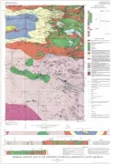
RODEO CREEK NE, NV
Geologic map of the Rodeo Creek NE quadrangle, Eureka County, Nevada
VEVAY SOUTH/VEVAY NORTH PARTS, KY
Geologic map of parts of the Vevay South and Vevay North quadrangles, north-central Kentucky
CHICKEN CREEK EAST, WY
Geologic map of the Chicken Creek East quadrangle, Sweetwater County, Wyoming
FERRIS, WY
Geologic map of the Ferris quadrangle, Carbon County, Wyoming
ISHPEMING - BEDROCK GEOLOGY, MI
Bedrock geologic map of the Ishpeming quadrangle, Marquette County, Michigan
TAMAQUA, PA
Geologic map of the Tamaqua quadrangle, Carbon and Schuylkill Counties, Pennsylvania
WILSON, KY
Geologic map of part of the Wilson quadrangle, Henderson County, Kentucky
STATE LINE - BEDROCK GEOLOGY, MA
Bedrock geologic map of the State Line quadrangle, Columbia County, New York, and Berkshire County, Massachusetts
WICKLIFFE/WYATT PART OF, KY
Geologic map of the Wickliffe quadrangle, Kentucky-Missouri, and the part of the Wyatt quadrangle in Kentucky
HYANNIS, MA
Geologic map of the Hyannis quadrangle, Barnstable County, Cape Cod, Massachusetts
ALBERTON, MT
Geologic map of the Alberton quadrangle, Missoula, Sanders, and Mineral Counties, Montana
NATWICK - SURFICIAL GEOLOGY, MA
Surficial geologic map of the Natick quadrangle, Middlesex and Norfolk Counties, Massachusetts
GOLCONDA, NV
Geologic map of the Golconda quadrangle, Humboldt County, Nevada