
GULF OF MEXICO

Simple Bouguer gravity anomaly map of the Gulf of Mexico and adjacent land areas
CALIRFORNIA CENTRAL - AERO-GEO, CA
Aeromagnetic and generalized geologic map of parts of central California
WEST VIRGINIA - AEROMAGNETIC SHT1, SOUTH
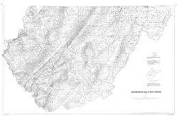
AEROMAGNETIC MAP OF WEST VIRGINIA - SOUTH HALF
PENNSYLVANIA WEST - AEROMAGNET, PA
Aeromagnetic map of Pennsylvania
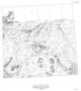
PARADISE RANGE - AERO/GEOLOGIC, NV
Aeromagnetic and generalized geologic map of the Paradise Range area, Nevada
NEW YORK SHEET 1 LOWER HUDSON, NY
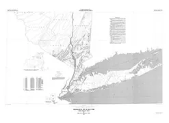
Aeromagnetic map of New York
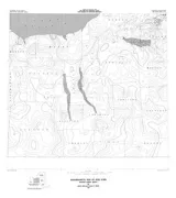
MONTANA - AEROMAGNETIC SHT1, EAST
Aeromagnetic map of Montana, East Half
UNITED STATES SOUTHEAST - AERO, US
Aeromagnetic map of part of the southeastern United States
NEW YORK SHEET 3 FINGER LAKES, NY
AEROMAGNETIC MAP OF NEW YORK FINGER LAKES SHEET
DIGITAL BOUGUER GRAVITY UNITED STATES
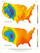
Digital colored residual and regional Bouguer gravity maps of the conterminous United States with cut-off wavelengths of 250 km and 1000 km
ALASKA/HAWAII PART B, US
Composite magnetic anomaly map of the United States; Part B, Alaska and Hawaii
UNITED STATES CENTRAL MAG ANO, US
Digital magnetic-anomaly map of central United States description of major features
OHIO - TOTAL INTENSITY MAGNETI, OH
Residual total intensity magnetic map of Ohio
BOUGUER GRAVITY ANOMALY MAP OHIO, OH
Complete bouguer gravity anomaly map of Ohio
FREE-AIR GRAVITY ANOMALY MAP BERING SEA
Free-air gravity anomaly map of the central and northern Bering Sea