
NUMBER FOUR, NY
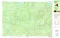
1:25 000 SCALE METRIC TOPOGRAPHIC MAP OF NUMBER FOUR, NEW YORK
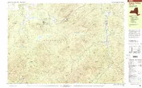
SANTANONI PEAK, NY
1:25 000 SCALE METRIC TOPOGRAPHIC MAP OF SANTANONI PEAK, NEW YORK
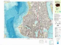
SEATTLE SOUTH, WA
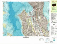
1:25 000 SCALE METRIC TOPOGRAPHIC - BATHYMETRIC MAP OF SEATTLE SOUTH, WASHINGTON
UNITED STATES - GRAVITY/TOPO, US

Isostatic residual gravity, topographic, and first-vertical derivative gravity maps of the conterminous United States
KABUL NORTH 30X60 QUADRANGLE AFG CD VER
Geologic and Topographic Maps of the Kabul North 30' x 60' Quadrangle, Afghanistan (CD version)
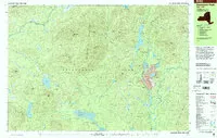
KEENE VALLEY, NY
1:25 000 SCALE METRIC TOPOGRAPHIC MAP OF KEENE VALLEY, NEW YORK
SEATTLE NORTH, WA
1:25 000 SCALE METRIC TOPOGRAPHIC - BATHYMETRIC MAP OF SEATTLE NORTH, WASHINGTON
TOL SOUTH, FM
Topographic map of Tol South State of Chuuk (formerly Truk) Federated states of Micronesia
ATLAS NORTHERN HEMISPHERE OF VENUS
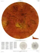
Atlas of Venus 1:15,000,000 topographic series, northern hemisphere
KIT, APPALACHIAN TRAIL MAPS
All the maps that make up the Appalachian Trail:
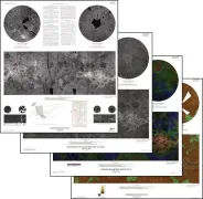
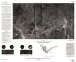
GEOLOGIC MAP OLYMPUS MONS REGION MARS

Geologic maps of the Olympus Mons region of Mars
USING GPS WITH MAPS, US
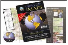
USING GPS WITH MAPS, DVD 13512 BY GPS OUTFITTERS INC. WINCHESTER, VA USA
THE PLANET VENUS IN FOUR MAP SHEETS
The planet Venus in four map sheets; 1, Radar image map of Venus; 2, Radar image and shaded relief map of Venus; 3, Altimetric radar image map of Venus; 4, Topographic map of Venus
GEOLOGIC STUDIES PLATTE RIVER, NEBRASKA
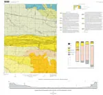
Geologic studies of the Platte River, South Central Nebraska and adjacent areas. Geologic maps, subsurface study, and Geologic History.
GUINEVERE PLANITIA REGION OF VENUS
The Guinevere Planitia region of Venus in four map sheets; 1, Radar image map of the Guinevere, Planitia region of Venus; 2, Radar image and shaded relief map of the Guinevere Planitia region of Venus; 3, Altimetric radar image map of trhe Guinevere Planitia region of Venus; 4, Topographic map of the Guinevere