
MAUI COUNTY SHEET 2, HI

FOLDER STATES MAP L-130
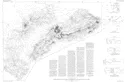
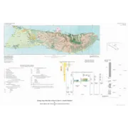
MAUI COUNTY SHEET 1, HI
MAUI COUNTY SHEET 1, US
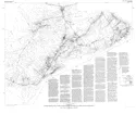
HALEAKALA NP - CRATER SECTION, HI
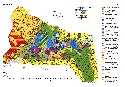
GEOLOGIC MAP OF THE CRATER SECTION OF HALEAKALA NATIONAL PARK MAUI HAWAII
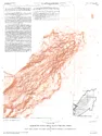
POTENTIAL HAZARDS VOLCANIC ERUPTIONS, HI
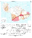
POTENTIAL HAZARDS FROM FUTURE VOLCANIC ERUPTIONS ON THE ISLAND OF MAUI, HI
PRELIMINARY MAP KILAUEA VOLCANO ERUPT
PRELIMINARY MAP SHOWING PRODUCTS OF ERUPTIONS, 1962-1974, FROM THE UPPER EAST RIFT ZONE OF KILAUEA VOLCANO, HAWAII
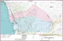
BATHYMETRIC GEOLOGIC MAP KEALAKEKUA, HI
BATHYMETRIC AND GEOLOGIC MAPS OF KEALAKEKUA BAY, HAWAII
AEROMAGNETIC MAP RIFT SYSTEM KILAUEA, HI
AEROMAGNETIC MAP OF THE RIFT SYSTEMS OF KILAUEA AND MAUNA LOA VOLCANES, ISLAND OF HAWAII, HAWAII
APPARENT-PERSISTIVITY RIFT KILAUEA, HI
APPARENT-PRSISTIVITY MAP OF THE RIFT SYSTEMS OF KILAUEA AND MAUNA LOA VOLCANOES, ISLAND OF HAWAII, HA
BATHYMETRY OF PUNA RIDGE KILAUEA VOL, HI
BATHYMETRY OF PUNA RIDGE, KILAUEA VOLCANO, HAWAII
DIALYSIS SAMPLERS AT HICKAM A F BASE,HI
Evaluation of passive diffusion bag and dialysis samplers in selected wells at Hickam Air Force Base, Hawaii, July 2001
LAVA INUNDATION,MAUNA LOA,SHT 9 OF 10,HI
Maps Showing Lava Inundation Zones for Mauna Loa, Hawaii Sheet 9 of 10
LONG TERM GAGING STATIONS, HAWAII
Trends in streamflow characteristics at long term Gaging stations, Hawaii
HAWAIIAN VOLCANO OBSERVATORY SUMMARY
Hawaiian Volcano Observatory summary 100; Part 1, Seismic data, January to December 2000 77pgs
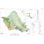
PLATE 4 GEOLOGIC MAP ISLAND MOLOKAI, HI
Geologic Map of the State of Hawai'i plate 4 of 8 <p> Plate 4, geologic map of the Island of O'ahu
PLATE 3 GEOLOGIC MAP ISLAND OF OAHU, HI
Geologic Map of the State of Hawai'i plate 3 of 8 <p> Plate 3, geologic map of the Island of O'ahu